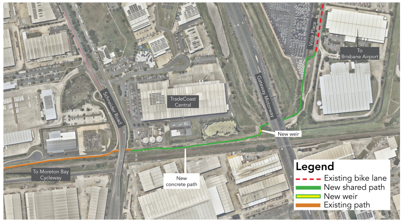


A new 600-metre shared path connecting the Moreton Bay Cycleway at the Schneider Road underpass in Eagle Farm to the Brisbane Airport precinct at Viola Place is now open, closing a long-standing gap in the cycling network that had frustrated northside riders for years.
The path, completed in late January 2026 after construction began in May 2025, gives cyclists, walkers and scooter riders a safe, continuous off-road connection between Eagle Farm and the airport for the first time. Dozens of cyclists turned out on opening morning to celebrate the new link, with a free pop-up coffee station set up along the path to mark the occasion.
For Ascot and Eagle Farm residents who commute to the airport precinct or connect to the broader cycling network from the northside, the new path removes the last significant off-road gap on this stretch of the Moreton Bay Cycleway. For riders arriving from Brisbane’s southside via the Gateway Bridge, it completes a critical northern link that previously forced cyclists onto road shoulders or into detours to continue their journey toward the airport and TradeCoast Central employment areas.
A Route Through the Gateway Motorway Corridor
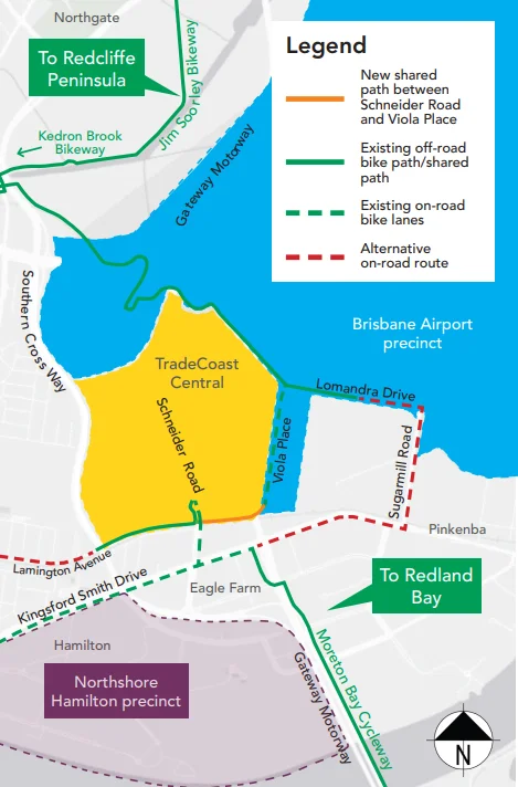
The new path begins at the existing cycleway at Schneider Road in Eagle Farm, passes under the Gateway Motorway, and connects to the existing bike lane and footpath at Viola Place inside the Brisbane Airport precinct. The network map shows how the connection slots into a broader web of routes: northbound from Viola Place, riders can continue along Lomandra Drive into the airport precinct, or pick up the Jim Soorley Bikeway toward Nundah, Northgate and the Redcliffe Peninsula. Southbound, the path connects to the Moreton Bay Cycleway running toward Redland Bay and the Gateway Bridge, as well as the Southern Cross Way off-road path and on-road options along Lamington Avenue and Kingsford Smith Drive toward Hamilton and Northshore.
For Eagle Farm and Pinkenba workers, the Schneider Road connection also creates the first direct off-road cycling link to the TradeCoast Central precinct from the south, avoiding the need to navigate Nudgee Road or Sugarmill Road on-road.
What the New Path Includes
The shared path varies between 2.5 and 3 metres in width, comfortably accommodating cyclists and pedestrians travelling in both directions. The path features solar-powered LED lighting along its full length for safe travel at all hours, a reconstructed weir and new waterway crossing where the path crosses a drainage channel near the Gateway Motorway, a kerb ramp at the Viola Place end for smooth access to the airport’s existing bike lane and footpath, and wayfinding signage and line marking throughout to guide riders unfamiliar with the route. Landscaping and turfing are also included, with minor tree removals carried out in consultation with a qualified arborist during construction.
Connecting Eagle Farm to a 150-Kilometre Network
The Moreton Bay Cycleway spans 150 kilometres of Brisbane’s coastline, connecting the Redcliffe Peninsula, the Sandgate and Shorncliffe foreshore, and the Wynnum and Manly foreshore to one another and to major inner-city bikeways. The cycleway links to the Gateway Bridge Bikeway, Kedron Brook Bikeway, Jim Soorley Bikeway and Gateway North Bikeway, and when complete may become one of the longest cycleways on Australia’s east coast spanning three local government areas.
The Gateway Bridge shared path, free for pedestrians and cyclists, is a busy crossing point used daily by commuter and recreational riders connecting Brisbane’s southside to the northside. With the Schneider Road link now in place, a rider can cross the Gateway Bridge from Murrarie, continue through Eagle Farm under the motorway, and reach the Brisbane Airport precinct, the TradeCoast Central employment hub or the Jim Soorley Bikeway entirely on off-road paths. That seamless connection is what active transport advocates in the area have sought for some time.
Around 25,000 people travel to Brisbane Airport each day for work, a number expected to grow by around 20,000 over the next two decades. Brisbane Airport’s draft 2026 Master Plan includes a series of active transport initiatives across the precinct, aimed at giving workers lower-cost and healthier commuting options as the airport precinct expands.
How to Access the New Path
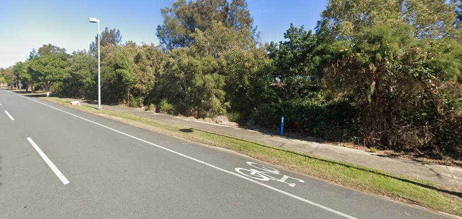
The new shared path is open at all hours. Riders approaching from the south can access the Schneider Road underpass from Kingsford Smith Drive via Lamington Avenue, or from the Moreton Bay Cycleway running north from the Gateway Bridge. Riders within the airport precinct can connect from Viola Place.
More information is available here. The project team can be reached on 07 3178 5413 during business hours, or 07 3403 8888 at any time.
Published 26-February-2026.